- Petrolink
- Technology
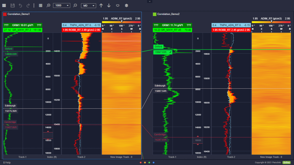
- Coral – Correlation in just three steps!

Building up a picture of the subsurface is a massive undertaking, one which takes thousands of hours and a diverse team. Everyone from drilling engineers, geologists and petrophysicists are involved. Unfortunately, on many projects, insights from planning in the office are not transferred to the well site. It is a long-standing issue and without closing the loop, there is a risk that wells will run over time and budget.
The Data Chasm
Even in a mature development field where tens of wells have been drilled and completed, the subsurface continues to surprise. You need to bring online as many tools as possible to improve the odds of success. One of the most powerful is offset well correlation.
Many will remember a time when correlation involved unfurling scrolls of well logs from dot-matrix printers and geoscientists commandeering the boardroom table. Technology has come a long way. Well log software packages have been around for a couple of decades. However, much of the work is still done with static data, leaving aside real-time information.
At many wellsites, correlation simply does not happen. Isolated from the corporate database and powerful software packages, many wellsite geologists are left in the dark. Often the only tangible document for the wellsite geologist to work from is a pre-spud report and if lucky, a rough map of the previous well locations.
Outstanding Offset Wells Every Time
The real benefit of correlation is the comparison of data, well to well. Sure, every well is unique but kickbacks in gamma-ray or resistivity spikes are some of the best clues to changes in formation. However, the whole workflow must be accelerated. Rigs move from well to well quickly and at times there is no chance to update the subsurface model and get this information back to the wellsite.
That is where Petrolink’s Coral module comes in. It marks the start of a whole new era. Generating correlation panels and comparing real-time data is now possible in just three steps.
Customizable Correlation
- Pick reservoir boundaries and assign formation markers, by correlating signatures from real-time well data with historical offset wells.
- Make comparisons across wells with a ghosting tool. Stretch and squeeze curves and formation lines to ensure you always stay on track.
- Use synchronized or individual scrolling across the panel.
- Show or hide offset wells to keep focused on what is important.
- Import LAS or WITMSL data to make legacy information available for comparison.
Picking casing points, calling TD or starting to build your sub-surface model? Time to stop your wellsite geologists relying on paper correlation panels.